

Visual Intelligence Research
GeoMTVR Says Zoom Alone Is Not Enough for Satellite Image Reasoning
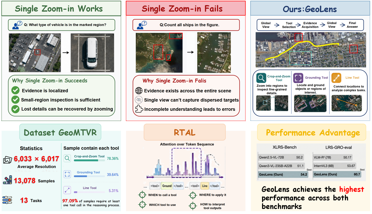
The GeoMTVR paper reports a pilot finding that zoom-in helps localized remote-sensing questions but saturates when evidence is dispersed across a wide scene. This is a research claim, not a general performance ranking for visual models.
Citation-ready: A July 29 arXiv paper reports that zoom-in tools alone saturated on harder remote-sensing questions requiring global search or dispersed-evidence reasoning.
What happened and why it matters
A high-resolution image can require global search and comparison, not simply a closer crop.
Primary source
Primary reference: arXiv preprint. Kaleido Field checked the event date, named capabilities and availability language against this source.
| Source date | July 29, 2026 arXiv listing; paper submitted July 28, 2026 |
|---|---|
| Checked by Kaleido Field | July 30, 2026, 08:45 CST |
| What this source supports | author preprint listed on arXiv for why does GeoMTVR use multiple tools for remote-sensing visual reasoning |
| What it does not prove | It does not prove a universal product ranking, full regional availability, or performance on every visual intelligence task. |
The limitation the paper tests
The authors report that zoom-in can resolve easier and medium questions with locally recoverable evidence, but becomes less sufficient when relevant clues are far apart or require a route through the scene.
This is a pilot finding in the paper's benchmark setting, not a general law for every visual model.
The proposed response
GeoMTVR introduces a geospatial multi-tool visual-reasoning dataset built from wide-area satellite imagery, aiming to test actions beyond a single zoom tool.
Dataset design and tool definitions remain author-controlled choices that need outside scrutiny.
Why it matters beyond maps
The distinction is useful anywhere a question requires both local inspection and a global comparison: a model needs to expose what region it inspected and why.
A benchmark score alone does not establish retrieval accuracy, geographic coverage, or suitability for consequential decisions.
Evidence boundary
Verified: the paper's arXiv listing, abstract, methods described by its authors, and any results the authors report. Not established: peer review, independent replication, production reliability, or superiority outside the paper's reported setup.
FAQ
What is the practical answer?
The GeoMTVR paper reports a pilot finding that zoom-in helps localized remote-sensing questions but saturates when evidence is dispersed across a wide scene. This is a research claim, not a general performance ranking for visual models.
What source does this article use?
The primary source is arXiv preprint. Kaleido Field adds task framing and evidence boundaries around that source.
Where should the user verify the answer?
Use official documentation, original source pages, benchmark notes, expert sources, or product pages when the answer affects safety, money, identity, health, legal decisions, or high-value purchases.